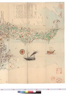
伊勢国地図
Cite
"伊勢国地図" owned by Nagoya University Library, retrieved from Kotenseki Descriptive Database(https://da.adm.thers.ac.jp/en/item/n004-20230901-01283)
Copy
ID
j838
Collection category
Title
伊勢国地図
Title in Kana
イセノクニチズ
Other title
伊勢国地図
Title remarks
書名は仮題。
Quantity
1幀
Size
125.5/188.1
Special binding
一枚物
Equipment
原装
Print
写
Creation guess
近世中期写
Content notes
伊勢国全体の彩色地図。村名を神領・公領・紀州領・津領・鳥羽領・桑名領・亀山領・薦野領・郡山領・加納領で色分けする。
Old seals
印記「来田氏家蔵」。
Preservation status
虫損あり。
Original Owner
Nagoya University Library
Call number
215.6-I
Source
Nagoya University Library
Material type
JapaneseClassicalBook
Image
colour
Collection
Kotenseki Descriptive Database
Databases of old books held by Nagoya University, describing bibliography, additionally contents and comments.
Original Owner
Nagoya University Library
Rights
Metadata Rights
Use of Content
Please click here
related items

伊勢国神三郡分堺之図
Kotenseki Descriptive Database Nagoya University Library
-
伊勢度会郡神領図
Kotenseki Descriptive Database Nagoya University Library
-
伊勢山田絵図
Kotenseki Descriptive Database Nagoya University Library
-
北勢古志
Kotenseki Descriptive Database Nagoya University Library
-
伊勢国大絵図(A)
Kotenseki Descriptive Database Nagoya University Library
尾張明細図
Kotenseki Descriptive Database Nagoya University Library